

سکیل فیکٹر کیا ہے اور اسے سروئینگ میں کیسے استمعال کیا جاتا ہے ؟؟؟
کسی بھی فاصلہ یا کوارڈی نیٹس کو ایک زون سے دوسرے زون میں تبدیل کرنے کے عمل کو سکیل فیکٹر کہا جاتا ہے حقیقت میں سکیل فیکٹر کرو سرفیس (Geodetic Distance) اور سٹریٹ سرفیس (Grid Distance) کے درمیان فرق کو واضح کرتا ہے اور اس عمل کے تحت ہم کرو سرفیس پر کام کرنے کیلئے جی پی ایس استمعال کرتے ہیں جس سے حاصل ہونے والے ڈیٹا کو یوٹی ایم کوارڈینیٹس کہا جاتا ہے جبکہ سٹریٹ سرفیس پر کام کرنے کے لیئے ہم ٹوٹل اسٹیشن استمعال کرتے ہیں جس سے حاصل ہونے والے ڈیٹا کو ٹرو کوارڈینیٹس کہا جاتا ہے یہ ہی وجہ ہے کہ جی پی ایس اور ٹوٹل اسٹیشن سے حاصل ہونے والے ڈیٹا میں فرق ہوتا ہے اور ان دونوں کے درمیان فرق کو ہی سکیل فیکٹر کا نام دیا گیا ہے۔
Whether a Surveyor uses GPS, Total Station, or both, scale factor cannot be ignored. The challenge for Surveyors is to use GPS without misunderstanding what the scale factors are. This will only become more complicated when introducing a Total Station that produces ground distances, integrated with GPS, that produces coordinates that are related to a predefined datum.
For Example:
The Measuring Distance from GPS = 103.453 m (WGS84
Measuring Distance from Total Station = 103.395 m
GPS to True = 103.395 / 103.453 = 0.99943936 (Scale Factor
GPS distance x 0.99943936 (SF) = True distance…

Scale Factor and Convergence
Three optional output fields for Interactive and Point Database Conversions are Scale Factor, Convergence, and Orthometric Height Scale. These fields only apply when a projected coordinate system is chosen as the output system. Orthometric height scale will only display when a Vertical Reference is selected. Points in a Geodetic systems do not have a scale or convergence.
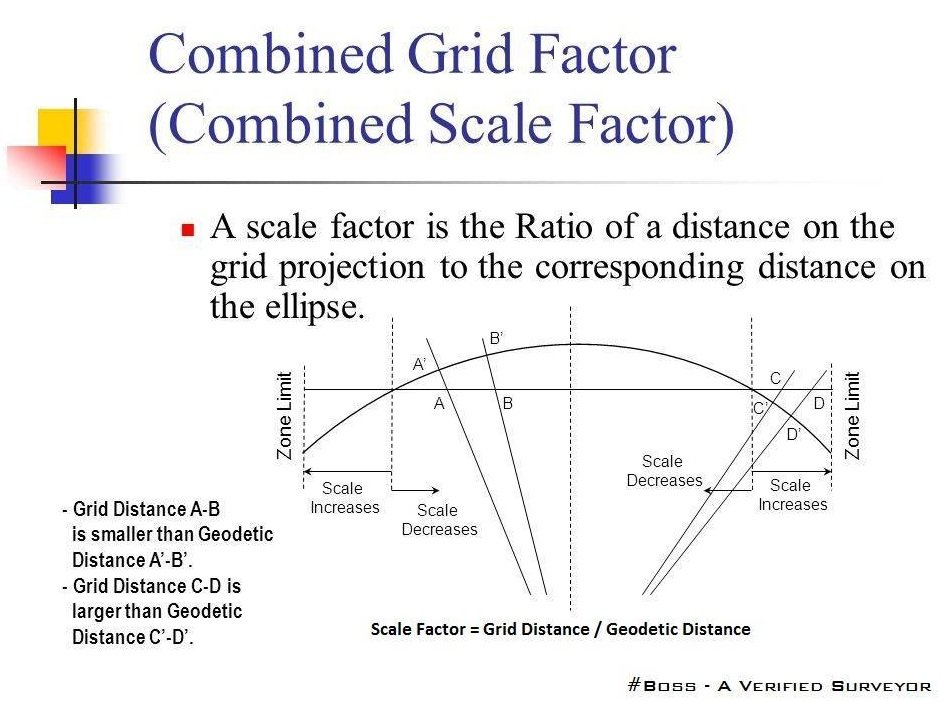
Grid Scale Factor
Grid Scale Factor, often simply called “Scale Factor” is a measure of distortion at a given point on a projected map. The scale factor is not cartographic scale, but a factor used to calculate actual ellipsoidal distances rather than distances on the projected surface.
Convergence
Convergence is the angle of difference in direction from Grid North to True North. This will vary across a projected coordinate system and can be used as a measure of accuracy of angular measurements at a given point on the map.
Note: In Transverse Mercator projected coordinate systems, convention is to specify the convergence angle from True North to Grid North.
Orthometric Height Scale
Also known as Elevation factor, Orthometric Height scale represents a factor of elevation that can be used to calculate geodetic distances above or below the ellipsoid (also known as reducing to the ellipsoid). This scale is determined using a constant radius for the earth in the area of the calculation, but this is typically considered accurate enough for most applications.
Other Post
-
Transition Curve In Highways – Purpose-Requirements-Example
-
How To Find The Coordinates Of Point P With The Help Of Point A & B
-
How To Calculate The Horizontal Distance Using With Auto Level Machine
Combined Factor
Combined Factor is simply Grid scale multiplied by the Orthometric Height Scale. This factor is used to calculate ellipsoid distance from a grid distance above or below the ellipsoid.
Example:
The Grid Scale for two points is 0.999689, and the Orthometric Height scale for the points is 0.999999123, the combined factor is: 0.999689 x 0.999999123= 0.999688123272747
If the grid surface distance between the two points is 1000 meters, to calculate ellipsoid distance between the two: 0.999688123272747 x 1000meters = 999.69 meters
Learn More
How To Calculate Height In Surveying With Angle & Distance
Scale Factor
For most Total Station or Robotic applications, the Scale Factor should be set to
1.0. The scale factor represents the “combined” grid/elevation factor that reduces
ground distances to grid. Therefore, for total stations, the scale factor acts as a
multiplier. All distance measurements, taken by a total station will be multiplied by the
scale factor. For GPS, the scale factor acts as a divisor. All GPS coordinates will also
be divided by the scale factor. In this way, the same “ground to grid” number can be
used to convert total station shots to the grid, or alternately to convert GPS shots to the
ground.
To match the coordinates of any standard transformation (e.g. UTM, NAD83), the
scale factor should be set to 1.0
When configured to total stations, the Calculate option will calculate the
combined grid/elevation factor from any entered coordinate—based on your current
state plane zone setting. This can allow you to go “ground to grid,” to typically reduce
the distance measured by total station to the sea level grid distance of GPS.
If set to a GPS configuration, Calculate becomes Read GPS. The Read GPS
option {in Job Settings / Units} is ghosted if a multi-point localization is active. In that
case, the scale factor is fixed by the localization itself, and is the inverse of the value
appearing in localization, because within Units, we display the “ground to grid” number,
whereas in localization, we display the “grid to ground” multiplier.
For base or 1-point rover localizations, Read GPS applies. After converting the
LAT/LONG from the GPS to the state plane coordinates and computing the grid and
elevation factors, the Scale Factor is applied as the final adjustment to the coordinates.
This adjustment is used on the X,Y and not the Z.
In GPS, the Scale Factor is applied by dividing the distance between the
coordinate and a base point by the Scale Factor. The coordinate is then set by starting
from the base point and moving in the direction to the coordinate for the adjusted
distance. The base point is the first point appearing in the GPS Localization option. If
there are no points specified in Localization, then 0,0 is used as base point.
The Scale Factor can be entered directly or calculated using the grid factor and
elevation for the current position. When using the current position, the program will read
the LAT/LONG from the GPS receiver. The scale factor is then calculated as: (State
Plane Grid Factor – (Elevation/Earth Radius)). A scale factor can be used to make grid to-ground conversions between identical points, to adjust the lesser sea level distances
of GPS to the ground (greater) distances measured by total stations whenever you are
above sea level. The grid to ground scale factor is lower at higher elevations because it
acts as a divisor (the scale factor is always defined as “ground to grid”).
Other Post
-
How To Calculate The Height Of Any Buildings And An Objects Using With Theodolite
-
What is Difference Between Whole Circle Bearing and Quadrantal Bearing
-
Transition Curve In Highways – Purpose-Requirements-Example
-
How To Find The Coordinates Of Point P With The Help Of Point A & B
In summary, when configured to GPS, the scale factor (typically less than 1 – i.e.
0.9999544) can be used to go “grid to ground” through division and when configured to
total stations, the scale factor (typically less than 1 – i.e. 0.9999544) can be used to go
“ground to grid” through multiplication. It can also be used for any other scaling purpose
desired, but be advised that any scale factor used for GPS is used as a divisor.
Because there are two potential uses of the scale factor (to adjust GPS measurements
and to adjust total station measurements), 2 distinct scale factors are stored and
recalled for any job, one for when you are configured to a GPS instrument and one for
when you are configured to total stations.
Please note:- if you are using GPS equipment and you add in Rover Based localization
points in the Equip tab / Localization / Points tab — the GPS Scale Factor shown in the Points
tab will be Greater than 1 {i.e. – 1.0000456}. When you save the Rover Localization and tap the
“GPS” tab you will see the inverse {1/x} value grayed out to 0.9999544 or something less than
1.
Learn More
Super-elevation And Design Formula | Advantages | Highway Engineering