Clicky

Home / Land Surveying

Land Surveying

Land Surveying

How to Calculate the RL by HI method in surveying

Hight of Instruments

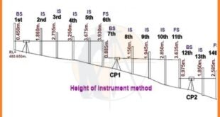
How to Calculate the RL by HI Method in Surveying. In this article i will explain how to Calculate the RL by HI method in surveying, Let us consider an example as given below. The leveling instrument was used to observe the subsequent readings. 0.450, 1.860, 2.755, 3.250, 3.675, 3.930, 0.885, …

Read More »

Civil Engineering Basic Knowledge

Civil Engineering Basic Site Knowledge

Civil Engineering Basic Site Knowledge. Useful Information For Land Surveyors And Civil Engineers. Get Benefits And Share With Others. Definition and Scope: Civil engineering is a branch of engineering that deals with the design, construction, and maintenance of infrastructure, including buildings, bridges, roads, dams, and other large-scale projects essential for …

Read More »

What is The Contour Mapping

What is Contour Mapping

Contour Mapping – Characteristics, Methods & Uses. The Contour are the lines joining the points of equal elevation on the surface of earth or we can say that the contour is a line in which the ground surface is intersected by the level surface obtained by joining points of the …

Read More »

Types Of Curves In Surveying Work

Curve

Types Of Curves In Surveying Work. What Is The Curve? The Curves are generally the horizontal &/or vertical bends that are usually used on highways & the railways when it is necessary to change the alignment of the route. when 2 points are located at the different levels, it becomes …

Read More »

Rise and fall method with Examples

what is intersight

Rise and fall method with Examples. In This Article i will discuss About the topic of Rise and Fall Method with Complete Detail. Rise & fall is the method of Land Surveying to solve the levelling to find out difference in elevation & elevation of 2 points. In this method …

Read More »
error: Content is protected !!