 Surveying & Architects A unique platform of Civil Engineering
What is Alignment of The Road ?
The position occupied by the center line of the Road in plan is called alignment of road. The new road should be aligned very carefully as the cost of the Construction, maintenance, safety & ease in travel etc. depends much upon the alignment of the road.
Once the construction of road is completed, the alignment of road cannot be changed. It is difficult to change the alignment after the completion of the road construction.
Due to increase in the cost of land & Construction of costly roadside structures, it is difficult to change the road alignment post the construction. Hence road alignment should therefore, be carefully selected & located.
Requirements of an ideal Alignment of The Road.
The following are the basic requirements of an ideal road alignment.
- Easy
- Short
- Economical
- Safe
- Utility
- Natural aspects
1 – Easy
The alignment must be easy in the construction, maintenance & traffic operations. The alignment should be easy for the operation of the vehicles with easy gradients & curves to meet this requirements.
2 – Short
In between 2 terminal station the alignment should be as short as possible. Short alignment provide economy in the cost of the construction, maintenance & transportation.
Learn More
-
Linear Measurements in the Surveying by Direct Method
-
Transition Curve In Highways – Purpose-Requirements-Example
-
Super-elevation And Design Formula | Advantages | Highway Engineering
-
What Is Difference Between Camber and Super Elevation In Road
The alignment should be as straight as possible to meet this requirements.
3 – Economical
The alignment should be economical in its cost of the construction, maintenance & traffic operations.
4 – Safe
The alignment should be safe for the traffic operation. To fulfill this requirement, the alignment should be safe enough for the construction and maintenance from the view point of stability of the natural hill slopes, embankment & cut slopes and foundation of embankments.
5 – Utility
The alignment should offer maximum utility by serving maximum population by connecting intermediate important towns & group of the villages.
6 – Natural Aspects
The alignment should pass through regions of the natural beauty & scenery to have good natural aspects.
Factors Affecting Alignment of The Road.
Various factors affecting the alignment of road are as follows.
- Need of traffic
- Purpose & class of the road
- Obligatory points
- Curve
- Gradient
- Sight distance
- Number of the drainage crossing
- Railway & river crossing
- Obstruction
- Formation bed
- Earthwork
- Availability of the labor & material
- Existing right of way
- Lengthy straight route
- Aesthetical aspect.
1 – Need of Traffic
Alignment should suit need of the traffic. For fast moving traffic it is must be as straight as possible. For slow moving traffic, like bullock cart & other it may have sharp bend.
2 – Purpose and Class of Road
The alignment should be selected according to the purpose & class of road. The national highway connecting 2 important towns should be kept perfectly straight as far as possible.
On the other hand alignment of the other category of road can be deviated when straight alignment is not feasible.
3 – Obligatory Points
The alignment should pass through obligatory points such as intermediate important towns, group of the villages & area of the commercial, political, military & social importance.
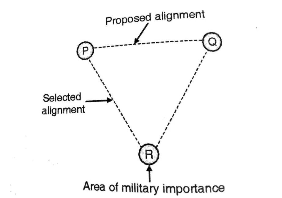
Hence to the connect obligatory points alignment may be changed.
4 – Curve
Curves must be as flat as possible. It is may be necessary to make adjustment in the horizontal alignment of the roads keeping in view the minimum radius of the curve & the transition curves.
5 – Gradient
While aligning the new road, the gradient should be flat & less than the ruling or design gradient. Thus in order to avoid excessive fall or rise the alignment is to be changed.
Learn More
-
What is The Benefits and Drawbacks Of Total Station.
-
What is Drone Surveying And Benefits Of the Drone Surveying.
-
Why Camber is Provided in Road Construction
6 – Sight Distance
The minimum sight distance, which should be available in every section of road, is the safe stopping distance for the fast moving vehicles.
Also there should be enough distance visible ahead for the safe overtaking operations of vehicles moving at design speed on the road. Hence the alignment should be the finalized in such a way that it should provide good sight distance.
7 – Number of the Drainage Crossing
The alignment should have minimum number of drainage crossing. To have maximum number of drainage crossing alignment must be changed.
8 – Railway & River Crossing
The alignment should cross river or the railway line at the right angles. In case of the river crossing point, it should fulfill the essential requirements of the good bridge site.

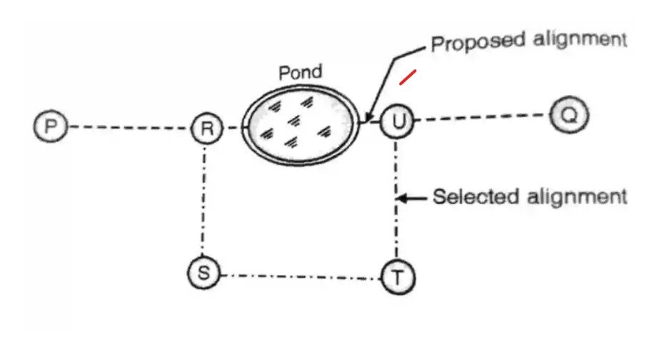
9 – Obstruction
Alignment should be free from the obstruction. Hence alignment can be changed to avoid well, lake, pond, historical & religious buildings etc.
10 – Formation Bed
The Alignment should run on the good soil as far as possible. Hence to fulfill this requirement alignment can be changed.
11 – Earthwork
The alignment should have less earthwork. Hence to avoid the excessive cutting or filling, the alignment must be changed.
12 – Availability of the Labour
The alignment should provide proximity to the labour & material required for the construction of the road. Hence to make construction & maintenance of the road economical, alignment of the road is changed.
13 – Existing Right of the Way
The alignment should make use existing right of the way. Hence to satisfy the requirement, alignment is changed in the order to curtail the cost of the land acquisition.
14 – Lengthy Straight Route
The alignment should not be monotony caused due to lengthy straight routes. Hence alignment must be have slight bend to break the monotony & to keep the driver alert.
15 – Aesthetical Aspect
The alignment can be changed in the order to pass the road through regions of the natural beauty & scenery.
Learn More
-
How To Measure Quantity Of Sand In Truck & HAIWA
-
Basic Estimation And Quantity Of Materials For Brick Wall, U.C.R. Masonry Plastering And Tiles
Survey Operations During Fixing Alignment Of The Road.
The following Survey operation should be done with the great accuracy during fixing the alignment of the road.
(a)
The center line of road is transferred from the map on the ground, by using transit theodolite & fixing the stakes at fifty m intervals in the plain terrain and at twenty m intervals in the hilly terrain along the center line in the direction of progress of the survey.
All the angles at intersections are to be measured using transit theodolite by using the double reversal method.
(b)
The angles of the intersections at the road crossing with the center line should be measured with the help of the transit theodolite.
(c)
The reference points for the center line should be located carefully so that during construction of road they will not be disturbed. These reference points should be properly describe & well located so that they will be helpful for the final drawings.
(d)
The distance measurement along the center line of road including curved portion should be done continuously.
(e)
The starting & end points of all the Curve namely beginning transition curve and circular curve should be fixed and provided with the references.
Other Post
-
How To Calculate The Quantity Of Bricks in 1 m3
-
How To Calculate The Height Of Any Buildings And An Objects Using With Theodolite
-
Structural load calculation on beam column slab and wall
One comment
Pingback: Civil Engineering Basic Knowledge - Surveying & Architects