 Surveying & Architects A unique platform of Civil Engineering
Interview Questions and Answers For Land Surveying
R u gearing up for an interview in the Civil Engineering for The Land Surveyor position? Congratulations on taking the step toward a rewarding career! To help u ace your upcoming interview, we have compiled the comprehensive list of the top 105 interview Q & A on Land Surveying.
This invaluable resource covers a wide range of the topics, from basic concepts to advanced techniques, ensuring u are well-prepared and the confident to tackle any question your interviewer may ask. So, get ready to impress your potential employer with your knowledge and expertise in the surveying, and embark on a successful journey in this fascinating and amazing field.

What is Land Surveying in Civil Engineering?
Land Surveying in the Civil Engineering is measuring & mapping the positions, distances, angles, & elevations of the features on the Earth’s surface. It is the fundamental aspect of the civil engineering projects, providing critical information for designing, planning, and constructing various structures and infrastructure, such as roads, bridges, buildings, and pipelines.
Land Surveying helps engineers understand the site’s conditions, determine accurate dimensions, establish boundaries, and the create precise layouts for Construction projects. By employing various techniques and instruments, Surveyors collect data that enable civil engineers to make informed decisions and ensure that projects are completed accurately and efficiently.
Confused about the right job role for u in the civil engineering? Take our Civil Engineering Career Choice Test to discover the perfect fit based on your interests and skills and the start your journey toward a fulfilling career in industry.
Top 105 Interview Q & A on Land Surveying Subjects in Civil Engineering
Preparing for an interview in the Land surveying field can be daunting, as there are numerous aspects to consider. To help u succeed, we have compiled the list of Land surveyor Q&A that cover a wide range of the topics.
This is includes building surveying interview questions that delve into the intricacies of the assessing structures and their condition, Civil Engineering Surveying Interview Questions that focus on relationship between Land Surveying and Civil Engineering projects, and total station survey interview questions which explore the technical aspects of the using total stations for precision measurements.
Additionally, our list contains digital Land Survey interview questions to help u understand the latest technologies used in the industry, land Surveyor interview questions that address the legal, ethical, and technical aspects of the land surveying, and general Surveyor Q&A that cover a broad spectrum of topics in the field.
By studying these Questions, u will be well-prepared & confident to face any interview scenario in the surveying domain. Here are the 105 mostly asked Interview Q & A on Land Surveying Subjects in the Civil Engineering;
1 – Can U define Land Surveying?
Land Surveying is the process of determining the relative positions of the points on or near the Earth’s surface by measuring angles, distances, & the elevations. It is used in the various Civil Engineering applications, such as construction, transportation, & mapping.
Learn More
How to Import Points Create Surface and Calculate Volume In AutoCAD Civil3D
Civil Engineering Basic Knowledge
2 – What is the different types of Surveying?
There are several types of the surveying, including:
-
Land Surveying.
-
Construction Surveying.
-
Topographic Surveying.
-
Hydrographic Surveying.
-
Mining Surveying.
3 – What are the instruments used in the Surveying?
Several instruments are used in the Surveying, including:
-
Total Station.
-
Theodolite.
-
GPS receiver.
-
Level.
-
Measuring tape.
-
Prism pole.
4 – What are the advantages of using the Total Station in the Surveying?
Total Station is an electronic instrument used in the surveying. Some of the advantages of using the Total Station are:
-
High precision & accuracy.
-
Faster & more efficient than traditional Surveying methods.
-
Can measure both angles & distances.
-
Can store data for the future use.
5 – What is GPS in the Surveying?
The GPS, ( Global Positioning System ) is a satellite-based navigation system used in the surveying. It uses signals from GPS satellites to determine the precise location of the point on the Earth’s surface.
6- How do u calculate the area of the plot using Surveying techniques?
To calculate the area of the plot using surveying techniques, the following steps are typically followed:
-
Measure the perimeter of the plot using a measuring tape or Total Station.
-
Divide the plot into the smaller triangles or rectangles.
-
Measure the length & width of the each triangle or rectangle.
-
Calculate the area of the each triangle or rectangle using the formula for area.
-
Add the areas of all the triangles or rectangles together to get the total area of plot.
7 – What is the benchmark in Surveying?
The benchmark in the surveying is a permanent, stable point with a known elevation. It is used as the reference point for other elevation measurements in the area.
8 – How do u find the elevation of the point using surveying techniques?
To find the elevation of the point using Surveying techniques, the following steps are the typically followed:
-
Set up the level near the point to be measured
-
Measure the elevation of the benchmark near the point
-
Measure the height of the level above the benchmark
-
Subtract the height of level from the elevation of the benchmark to get elevation of the point
9 – What is the purpose of the contour lines in Surveying?
The Contour lines in surveying are lines that connect points of equal elevation on the map. They are used to represent the shape & slope of the terrain, and to determine the location of the features such as hills, valleys, & the ridges.
10 – What are the different types of errors in the Surveying?
There are several types of errors in the surveying, including:
-
Systematic Errors: Errors that occur consistently & can be corrected.
-
Random Errors: Errors that occur randomly & cannot be corrected.
-
Blunders: Errors that occur due to the human error or equipment malfunction.
-
Gross errors: Errors that occur due to incorrect data entry or measurement.
11 – What is the difference between the Plane Survey and Geodetic Survey?
The plane survey is a survey conducted on the small area where the curvature of the Earth’s surface is negligible.
The Geodetic survey is a survey conducted on the large area where the curvature of the Earth’s surface must be taken into account.
12 – What is the purpose of the Traverse in the Surveying?
The traverse in the surveying is a series of connected lines that are measured in the order to determine the position of the points on the Earth’s surface. It is used to create the detailed map of the area being surveyed.
13 – How do u calculate the length of the line using Surveying techniques?
To calculate the length of the line using Surveying techniques, the following steps are the typically followed:
-
Measure the angle between the 2 endpoints of the line using the theodolite or Total Station.
-
Measure the distance between the 2 endpoints of the line using the measuring tape or Total Station.
-
Use trigonometry to calculate the length of line using the measured angle & distance
14 – What is the Topographic Map?
The topographic map is the map that shows the shape & elevation of the Earth’s surface. It uses contour lines to represent points of the equal elevation and is used in the surveying to create a detailed map of an area.
15 – What is the purpose of the level in Surveying?
The level in Surveying is used to determine the relative height of the different points on the Earth’s surface. It is used to create the detailed map of the area being surveyed.
16 – What is the vertical Angle in Surveying?
The vertical angle in surveying is the angle between the horizontal line & the line of sight that is directed upward or downward. It is used to measure the elevation of the point on the Earth’s surface.
17 – What is the purpose of the prism pole in the Surveying?
The prism pole in surveying is used to hold the prism or reflector that reflects light back to the Total Station. It is used to measure distances & angles.
18 – What is the horizontal Angle in the Surveying?
The horizontal angle in surveying is the angle between 2 lines on the horizontal plane. It is used to determine the direction of 1 point from another.
19 – What is the purpose of the plumb bob in Surveying?
The plumb bob in the surveying is used to determine the vertical alignment of the point. It is used to ensure that the point is directly above or below another point.
20 – What is the Traverse Station in Surveying?
The traverse station in surveying is the point on a traverse where measurements are taken. It is used to determine the position of the points on the Earth’s surface.
Learn More
-
What is The Contour Mapping
-
Types Of Curves In Surveying Work
-
How to calculate the RL of temporary benchmark on the site
21 – What is the purpose of the Survey Control Network?
The survey control network is the network of reference points that are used to establish the position & elevation of the points on the Earth’s surface. It is used to ensure the accuracy of the survey measurements.
22 – What is the Benchmark in Surveying?
The benchmark in surveying is the permanent, stable point with the known elevation. It is used as a reference point for other elevation measurements in area.
23 – What is the Reference line in Surveying?
The reference line in surveying is the line used as a reference for taking measurements. It is used to ensure the accuracy of Land Survey measurements.
24 – What is the purpose of the stadia rod in Surveying?
The purpose of the stadia rod in the surveying is to measure distances and the elevations. It has the graduated scale on it that allows the surveyor to measure the distance from the instrument to the rod and difference in elevation between the instrument and rod. The stadia rod is held vertically and the surveyor looks through the telescope of instrument to read the distance & elevation measurements. The stadia rod is an important tool for the Surveyors because it allows them to measure distances and the elevations quickly & accurately.
25 – What is the plumb line in Surveying?
The plumb line in surveying is the vertical line that is used to determine the alignment of the point or structure. It is used to the ensure that the point or structure is vertical.
26 – What is the difference between the spot elevation and the contour line in Surveying?
The spot elevation in surveying is the point on a map that represents the exact elevation of the particular point.
The contour line in surveying is the line that connects points of equal elevation on the map.
27 – What is the horizontal control network in Surveying?
The horizontal control network in surveying is the network of reference points that are used to establish the horizontal position of the points on the Earth’s surface. It is used to ensure the accuracy of the survey measurements.
28 – What is the vertical control network in Surveying?
The vertical control network in surveying is the network of reference points that are used to establish the vertical position of the points on the Earth’s surface. It is used to ensure the accuracy of the survey measurements.
29 – What is the Traverse in Surveying?
The traverse in surveying is the series of connected lines that are measured in the order to determine the position of the points on the Earth’s surface. It is used to create the detailed map of the area being surveyed.
30 – What is the purpose of the Magnetic Compass in Surveying?
The magnetic compass in the surveying is used to determine the direction of the magnetic north. It is used as the reference for taking measurements & determining the orientation of the structures.
31 – What is the purpose of the Survey Monument?
The survey monument is the physical marker that is used to mark the location of the point on the Earth’s surface. It is used as the reference point for future surveys & construction projects.
32 – What is the purpose of the Survey report?
The survey report is the document that summarizes the findings of the survey. It includes information about the location & condition of the structures, as well as recommendations for the future work.
33 – What is the GPS Receiver in Surveying?
The GPS receiver in the surveying is an electronic device that is used to receive signals from GPS satellites. It is used to determine the position and the elevation of points on the Earth’s surface.
34 – What is the baseline in Surveying?
The baseline in surveying is the measured line that is used as the reference for taking measurements. It is used to ensure the accuracy of the survey measurements.
35 – What is the difference between the level and a transit in Surveying?
The level in surveying is used to determine the relative height of the different points on the Earth’s surface.
The transit in surveying is used to measure horizontal and the vertical angles.
36 – What is the purpose of the plumb in Surveying?
The plumb in surveying is used to determine the vertical alignment of the point. It is used to ensure that the point is directly above or below another point.
37 – What is the purpose of the prism in Surveying?
The prism in surveying is used to reflect light back to the Total Station. It is used to measure distances & angles.
38 – What is the purpose of the dumpy level in Surveying?
The dumpy level in surveying is used to determine the relative height of the different points on the Earth’s surface. It is used to create the detailed map of the area being surveyed.
39 – What is the difference between the Closed traverse & an Open traverse in Surveying?
In thee surveying, The traverse is a series of connected survey lines that are used to determine the position of the points on the Earth’s surface. The traverse can be either closed or open, depending on it’s configuration.
40 – What is the difference between the transit & theodolite in Surveying?
The transit in surveying is used to the measure horizontal & vertical angles, while the theodolite is used to measure only horizontal angles.
Learn More
-
Rise and fall method with Examples
-
How to calculate The gradient, run and rise in civil construction
-
How To Calculate The Asphalt Quantity For Road Work
41 – What is the level loop in Surveying?
The level loop in surveying is the series of measurements taken around the closed circuit. It is used to determine the difference in elevation between 2 points.
42 – What is the purpose of the level book in Surveying?
The level book in surveying is used to record the measurements taken during the survey. It includes the information about the location and condition of the structures, as well as recommendations for future work.
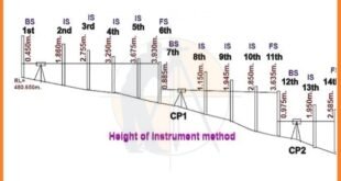
43 – What is the height of instrument in Surveying?
The height of the instrument in surveying is the height of a level above the benchmark. It is used to determine the elevation of the points on the Earth’s surface.
44 – What is the purpose of the Vertical Curve in Surveying?
The vertical curve in the surveying is used to connect 2 grades of different elevations. It is used to create the smooth transition between the 2 grades.
45 – What is the Meridian in Surveying?
The meridian in surveying is the line that connects the North & South Poles. It is used as the reference for taking measurements and determining the orientation of the structures.
46 – What is the setback distance in Surveying?
The setback distance in surveying is the distance between the structure and the property line. It is used to ensure that structures are located within the boundaries of property.
47 – What is the traverse adjustment in Surveying?
The traverse adjustment in surveying is the process of adjusting the measured distances & angles in the traverse to ensure that they are accurate.
48 – What is the purpose of the slope stake in Surveying?
The slope stake in surveying is used to mark the location of the point on a slope. It is used to ensure that structures are built on the level surface.
49 – What is the Map Projection in Surveying?
The map projection in surveying is the method of representing the Earth’s curved surface on the flat map. There are several different types of the map projections, each with their own advantages & disadvantages.
50 – What is the plumb rule in Surveying?
The plumb rule in the surveying is used to measure vertical distances. It is used to ensure that the point is directly above or below another point.
51 – What is the profile in Surveying?
The profile in surveying is the diagram that shows the vertical cross-section of the Earth’s surface. It is used to create the detailed map of an area.
52 – What is the datum in Surveying?
The datum in surveying is the reference point or surface used to measure elevations. It is used as the reference for taking measurements and determining the elevation of the points on the Earth’s surface.
53 – What is the break point in Surveying?
The break point in surveying is the point where the slope of the terrain changes. It is used to create the detailed map of an area.
54 – What is the reference mark in Surveying?
The reference mark in surveying is the mark that is used to mark the location of the point on the Earth’s surface. It is used as the reference point for future surveys & construction projects.
55 – What is the traverse table in Surveying?
The traverse table in surveying is the table that is used to calculate the coordinates of the points on a traverse. It includes information about the angles & distances measured in the traverse.
56 – What is the total error in Surveying?
The total error in surveying is the difference between the true value of the measurement and the measured value. It includes both systematic & random errors.
57 – What is the baseline measurement in Surveying?
The baseline measurement in surveying is the distance between 2 points on the baseline. It is used as a reference for taking measurements & determining the position of the points on the Earth’s surface.
58 – What is the Satellite Surveying System?
The satellite surveying system is the system that uses satellites to determine the position and elevation of the points on the Earth’s surface. Examples include GPS & GLONASS.
59 – What is the purpose of the data collector in Surveying?
The data collector in surveying is used to store and manage survey data. It is used to ensure that the data is accurate and organized.
60 – What is the traverse closure in Surveying?
The traverse closure in surveying is the difference between the sum of interior angles in the traverse and the total number of the right angles in the traverse. It is used to ensure the accuracy of the survey measurements.
Learn More
-
Types Of Scales In Surveying
-
What is Alignment of Road
-
Linear measurements in the surveying by Direct Method
61 – What is the hypsometric Curve in Surveying?
The hypsometric curve in surveying is the graph that shows the distribution of the elevations in an area. It is used to create the detailed map of the area being surveyed.
62 – What is the boundary survey in Surveying?
The boundary survey in surveying is the survey conducted to determine the boundaries of the piece of land. It is used to ensure that the structures are located within the boundaries of the property.
63 – What is the setback line in Surveying?
The setback line in surveying is the line that marks the distance between a structure and the property line. It is used to ensure that the structures are located within the boundaries of the property.
64 – What is the purpose of the Horizontal Curve in Surveying?
The horizontal curve in surveying is used to connect 2 lines of different direction. It is used to create the smooth transition between the 2 lines.
65 – What is the distance measurement in Surveying?
The distance measurement in surveying is the process of the measuring the distance between 2 points on the Earth’s surface. It is used to determine the position of the points on the Earth’s surface.
66 – What is an azimuth in the Surveying?
An azimuth in the surveying is the horizontal angle between the reference line and a line to the point of interest. It is used to determine the direction of the point from a reference line.
67 – What is the reference direction in Surveying?
The reference direction in surveying is the line used as a reference for taking measurements. It is used to ensure the accuracy of the survey measurements.
68 – What is the benchmark survey in Surveying?
The benchmark survey in surveying is the survey conducted to determine the elevations of the benchmarks. It is used as a reference point for other elevation measurements in the area.
69 – What is the precision level in Surveying?
The precision level in surveying is the level that is used to determine the relative height of the different points on the Earth’s surface with a high degree of accuracy. It is used to create the detailed map of the area being surveyed.
70 – What is the triangulation in Surveying?
The triangulation in surveying is the method of determining the position of the points on the Earth’s surface by measuring the angles between them. It is used to create the detailed map of the area being surveyed.
Learn More
Calculation For Road Work
The Role And Responsibilities Of Quantity Surveyor In Current Construction Sectors
ARC Length Formula And Details
How To Use a Dumpy Level Example
Geometry Formulas
71 – What is the control point in Surveying?
The control point in surveying is the point that is used as a reference for taking measurements. It is used to ensure the accuracy of the survey measurements.
72 – What is the leveling staff in Surveying?
The leveling staff in surveying is the graduated rod that is used to measure elevations. It is used to create the detailed map of the area being surveyed.
73 – What is the digital level in Surveying?
The digital level in surveying is the level that uses digital technology to measure elevations. It is used to create the detailed map of the area being surveyed.
74 – What is the Geodetic datum in Surveying?
The geodetic datum in surveying is the reference surface used to measure positions on the Earth’s surface. It includes information about the Earth’s shape & size, as well as its orientation in the space.
75 – What is the global navigation satellite system in Surveying?
The global navigation satellite system in surveying is the system that uses a network of satellites to determine the position and elevation of the points on the Earth’s surface. Examples include GPS & GLONASS.
76 – What is the property survey in Surveying?
The property survey in surveying is the survey conducted to determine the boundaries and characteristics of the piece of land. It is used to ensure that the structures are located within the boundaries of the property.
77 – What is the robotic total station in Surveying?
The robotic total station in surveying is the Total Station that is controlled remotely. It is used to measure the distances and angles with a high degree of accuracy.
78 – What is the traverse point in Surveying?
The traverse point in surveying is the point on a traverse where measurements are taken. It is used to determine the position of the points on the Earth’s surface.
79 – What is the purpose of the surveying instrument calibration in Surveying?
The surveying instrument calibration in surveying is the process of adjusting surveying instruments to ensure that they are accurate. It is used to ensure the accuracy of survey measurements.
80 – What is the vertical angle in Surveying?
The vertical angle in surveying is the angle between the horizontal line and a line of sight to a point of the interest. It is used to determine the elevation of the point.
Learn More
-
What is the Benefits and Drawbacks of Total Station
-
What is drone Surveying and benefits of the drone Surveying
-
House Plan 30 x 50
81. What is the traverse line in Surveying?
The traverse line in surveying is the line that connects 2 or more traverse points. It is used to determine the position of the points on the Earth’s surface.
82 – What is the traverse network in Surveying?
The traverse network in surveying is the network of connected traverse lines. It is used to create the detailed map of the area being surveyed.
83 – What is a traverse station in Surveying?
The traverse station in surveying is the point on a traverse where measurements are taken. It is used to determine the position of the points on the Earth’s surface.
84 – What is the vertical curve in Surveying?
The vertical curve in surveying is the curve that is used to connect 2 grades of different elevations. It is used to create the smooth transition between the 2 grades.
85 – What is the tacheometry in Surveying?
Tacheometry in surveying is the method of measuring distances & elevations using an instrument known as a tacheometer.
86 – What is the plane table survey in Surveying?
The plane table survey in surveying is the method of surveying where a flat table is used to create a detailed map of the area being surveyed.
87 – What is the photogrammetry in Surveying?
The Photogrammetry in surveying is the science of making measurements from photographs. It is used to create the detailed maps of an area.
88 – What is the trilateration in Surveying?
Trilateration in surveying is the method of determining the position of the points on the Earth’s surface by measuring the distances between them. It is used to create the detailed map of the area being surveyed.
89 – What is the least squares adjustment in Surveying?
The least squares adjustment in surveying is the method of adjusting survey measurements to ensure that they are accurate. It is used to ensure the accuracy of the survey measurements.
90 – What is the leveling circuit in Surveying?
The leveling circuit in surveying is the series of leveling measurements taken around the closed circuit. It is used to determine the difference in elevation between 2 points.
91 – What is the laser level in Surveying?
The laser level in surveying is the level that uses laser technology to measure elevations. It is used to create the detailed map of the area being surveyed.
92 – What is the slope in Surveying?
The slope in surveying is the steepness of the terrain. It is used to create the detailed map of an area.
93 – What is the coordinate system in Surveying?
The coordinate system in surveying is the system used to determine the position of the points on the Earth’s surface. It is used to ensure the accuracy of the survey measurements.
94 – What is the stadia rod in Surveying?
The stadia rod in surveying is the rod used to measure distances & elevations. It is used to create the detailed map of the area being surveyed.
Learn More
-
Why Camber Is Provided In Road
-
What Is Difference Between Camber and Super Elevation In Road
-
How To Calculate Horizontal Distance Using With Auto Level Machine
-
What is Difference Between Whole Circle Bearing and Quadrantal Bearing
95 – What is the satellite positioning system in Surveying?
The satellite positioning system in surveying is the system that uses satellites to determine the position and elevation of the points on the Earth’s surface. Examples include GPS & GLONASS.
96 – What is the survey line in Surveying?
The survey line in surveying is the line that connects 2 or more survey points. It is used to determine the position of the points on the Earth’s surface.
97. What is the base map in Surveying?
The base map in surveying is the map that is used as a reference for taking measurements. It includes information about the location & characteristics of the features in the area being surveyed.
98 – What is the vertical control point in Surveying?
The vertical control point in surveying is the point that is used as a reference for taking elevation measurements. It is used to ensure the accuracy of the survey measurements.
99 – What is the Geoid in Surveying?
The geoid in surveying is an equipotential surface that represents the Earth’s mean sea level. It is used as the reference surface for measuring elevations.
100 – What is the Topographic Map in Surveying?
The topographic map in surveying is the map that shows the surface features of an area in detail. It includes information about the elevation & slope of the terrain, as well as the location of the structures and other features.
101 – What is the control survey in Surveying?
The control survey in surveying is the survey conducted to determine the positions of control points. It is used as a reference for taking measurements in the future surveys.
102 – What is the plane surveying in Surveying?
The plane surveying in surveying is the type of surveying where the Earth’s curvature is not taken into account. It is used for the small-scale surveys.
103 – What is the cadastral survey in Surveying?
The cadastral survey in surveying is the survey conducted to determine the boundaries of the land ownership. It is used to create the legal documents & maps for property owners.
104 – What is the field book in Surveying?
The field book in surveying is the book used to record measurements taken during a survey. It includes information about the location & characteristics of the features in the area being surveyed, as well as calculations & notes.
105 – What is the traverse table in Surveying?
The traverse table in surveying is the table that is used to calculate the coordinates of the points on a traverse. It includes information about the angles & distances measured in the traverse.
Learn More
-
How To Calculate The Height Of Any Buildings And An Objects Using With Theodolite
-
Transition Curve In Highways – Purpose-Requirements-Example
-
How To Find The Coordinates Of Point P With The Help Of Point A & B
-
Calculate Height In Surveying With Angle & Distance
Conclusion.
Our comprehensive list of the top 105 interview Q&A on the Surveying subject serves as an invaluable resource for aspiring & experienced professionals in the Civil Engineering. By familiarizing yourself with these questions, u can gain the deeper understanding of the key concepts & techniques involved in the surveying, which will ultimately help u excel in your interviews & career.
Whether u are the recent graduate seeking your 1st job or an experienced engineer looking to the advance in your profession, this compilation of the surveying questions will equip u with the knowledge and confidence to tackle any interview scenario. Remember, The practice makes perfect, so take the time to review these Q & A continue to build your expertise in the surveying domain. Good luck.