Types Of Curves In Surveying Work. What Is The Curve? The Curves are generally the horizontal &/or vertical bends that are usually used on highways & the railways when it is necessary to change the alignment of the route. when 2 points are located at the different levels, it becomes …
Read More »How to calculate the RL of temporary benchmark on the site
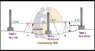
How to calculate the RL of temporary benchmark on the site. In this Article I will Discuss about the topic of How to calculate the RL of temporary benchmark on the site. Let us now go through the procedure of shifting And finding the RL of the temporary benchmark on …
Read More »Types Of Scales In Surveying
Types Of Scales In The Surveying. Since the Surveyed area is the very large, it is never possible to make full size of drawing. For convenience it is generally necessary to draw them to the reduced size, this operation is called ( drawing to scale). There are 2 types of …
Read More »Linear measurements in the surveying by Direct Method
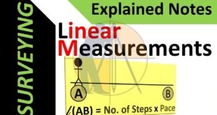
Linear Measurements in the Surveying by Direct Method The Linear measurements in surveying can be performed by mainly 3 methods namely direct method, electromagnetic methods & optical methods. The direct method is the common method that employs the chain, tape or any other instrument to measure the linear distance. Various …
Read More »What is the Benefits and Drawbacks of Total Station
What is the Benefits and Drawbacks of Total Station. Definition of the Total Station Now-a-days The Total Station is the most popular software for Land Surveyors to use on the job site. The total station is created by combining an electronic theodolite, an electronic distance measuring device (E.D.M) & a …
Read More »What is drone Surveying and benefits of the drone Surveying
What is drone Surveying and benefits of drone Surveying. In this article we will discuss about the topic of drone Surveying and Benefits. 1 – What is drone Surveying. A drone Survey is an aerial Survey to capture the aerial data of the Survey land from the different angles. Drones …
Read More » Surveying & Architects A unique platform of Civil Engineering


